↓
 

Cleveland Land Surveying

Local Land Surveyors in Cleveland, OH

Cleveland Land Surveying
  • Home
  • ALTA Survey
  • Boundary Surveying
  • Construction Survey
  • Drone LiDAR Mapping
  • Elevation Certificate
  • Land Surveying
  • Topographic Survey
  • Blog
  • Contact Us
Home - Page 2 << 1 2 3 4 … 8 9 >>

Post navigation

← Older posts
Newer posts →

Boundary Surveying for Vacant Lot Housing Revival

Cleveland Land Surveying Posted on July 6, 2026 by ClevelandSurveyorJuly 4, 2026
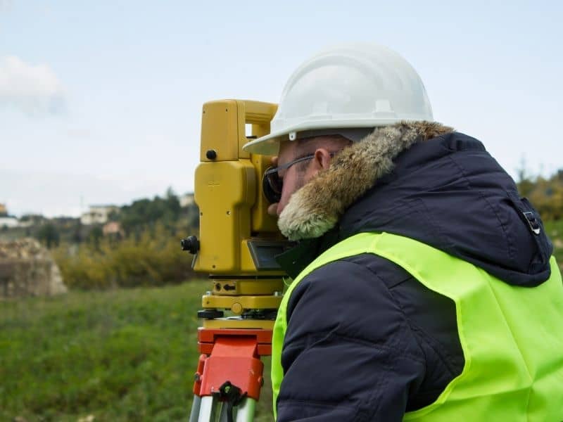
Surveyor using equipment to check boundary lines on open land before housing development.

Empty lots hold great promise for new homes but they also hide plenty of unknowns. Boundary surveying marks exact property lines before anyone draws plans or moves dirt so owners know exactly what land they hold. Many lots sit unused for years and old papers often leave out key details so guessing where one lot ends and another begins leads to big trouble once construction starts.

Rechecking Property Lines Before New Housing Plans

People often look at a vacant lot and assume the fence or road edge marks the true limit but that is rarely the case. Boundary surveying helps confirm lot limits before a vacant parcel is prepared for a new home or small housing project. Surveyors pull original records, measure the whole site and set fresh markers that match official land titles. This clears up any confusion right away so architects and planners work with facts instead of guesses.

Local rules also set how far buildings must sit from each line and wrong placement breaks those rules immediately. Even a small error can push a foundation into a setback zone or cross a neighbor’s land entirely. Checking lines first saves time and keeps plans on solid ground from the very start.

Identifying Boundary Evidence on Long Unused Lots

Lots that sit empty for a long time lose the signs that show where boundaries run. Grass and brush grow over old stakes, heavy rain washes away stone piles and people remove posts without realizing what they meant. Surveyors walk every part of the site to find whatever clues remain and they also look for signs that show where lines never ran at all.

Common clues that may still appear include:

  • Old concrete posts buried just below the soil
  • Curved tree lines that follow historic lot shapes
  • Changes in soil type that match old property divisions
  • Rusty iron rods hidden under thick grass or leaves

Helping Owners Avoid Building Too Close to Neighboring Land

Setting a foundation or driveway too near the edge causes fights and extra costs later. Accurate boundary information helps prevent layout mistakes near side or rear property lines because everyone sees the exact limits before work begins. Owners can then plan walls, parking and outdoor space that fit fully inside their own lot without touching land that belongs to someone else.

Neighbors often have their own ideas about where lines sit and clear survey marks stop arguments before they start. If a fence or shed already sits in the wrong spot the survey also shows that owners can fix it before adding more work.

Supporting Clear Site Decisions for Builders and Buyers

Builders and buyers both need to know exactly what space they can use and what space they must leave alone. Survey results help decide where structures, driveways, fences and future improvements may belong because every choice ties back to the measured lines. Builders can place homes and utilities in spots that fit rules and buyers see exactly what land they will own once the deal closes.

Creating Confidence Before Vacant Land Becomes Housing

Spending money on plans, permits or materials feels risky when no one is sure of the lot shape. Boundary surveying gives housing revival projects a more reliable start by confirming the parcel before investment flows in. Owners, lenders and local officials all trust a project more when the lines stand clear and proven.

This step also makes future sales or transfers easier because the survey stays as a trusted record. No one has to repeat old mistakes or wonder if the lot size matches what was promised years ago.

Frequently Asked Questions

Why survey a vacant lot before building housing?

A survey confirms the property limits before design permitting fencing or construction decisions are made. It also shows if any part of the planned work sits outside the lot or breaks local rules.

Can vacant lot markers disappear over time?

Yes. Markers can be buried, damaged, removed or hidden by overgrowth. Old references also fade or vanish so new field work is the only way to get accurate lines.

How does boundary surveying help home builders?

It gives builders accurate property limits so they can plan improvements in the correct location. It also helps them avoid delays, fines or disputes that come from building in the wrong spot.

Is boundary surveying useful before buying vacant land?

Yes. It helps buyers understand exactly what land they are purchasing. It also reveals if any part of the lot has unclear limits or existing conflicts before they pay for the property.
Posted in boundary surveying | Tagged boundary survey

From Abandoned Buildings to New Investments: Why ALTA Surveys Matter

Cleveland Land Surveying Posted on July 2, 2026 by ClevelandSurveyorJune 30, 2026
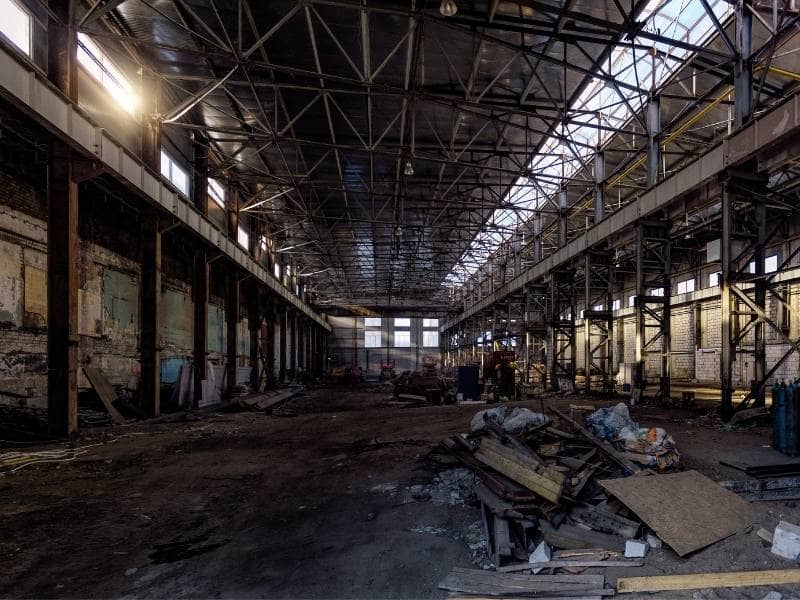
Interior of an abandoned commercial building illustrating a property evaluated with an ALTA Survey before redevelopment, renovation, or commercial investment.

Empty buildings and unused commercial sites often look like blank slates ready for new life. Investors see space, location, and room to grow, but they also face hidden layers of history and rules. An ALTA survey reveals the full picture of what sits on and around the land. It turns guesswork into clear facts so you can decide if the site truly fits your redevelopment goals.

Many older or vacant properties have changed hands many times, and records may be incomplete or outdated. What looks like open space could come with restrictions, existing structures, or rights that limit how you can build. Starting with an ALTA survey gives you the confidence to move forward with a solid plan.

Seeing Redevelopment Potential Beyond a Vacant Property

When you look at an abandoned warehouse, closed shopping center, or empty office block, you only see what is visible. You cannot see where the legal lines end, which parts belong to the property, or what rights others may have to use the land. The layout you see today may not match the official description written in deeds or maps.

Some sites appear large enough for big plans, but setbacks, easements, or old agreements may shrink the usable area. Others have boundaries that shift from what fences or curbs suggest. An ALTA survey digs into those records and compares them to the actual ground. It shows you exactly what you own and what rules apply, so you can judge the true potential before investing time or money.

Existing Site Improvements Can Shape Every Redevelopment Decision

Even when buildings sit empty, they leave behind features that stay in place. You may find old parking lots, loading ramps, utility lines, access roads, sidewalks, or foundation remains. Some of these items can be reused to lower costs, while others may be in the way or not allowed under current rules.

Knowing exactly where each feature sits helps you decide what to keep, what to fix, and what to remove. For example, a well-placed driveway can save you from building a new one, but a utility line running through the center of the lot may change your entire design. An ALTA survey maps all these details clearly. It gives you a reliable base to plan how the site will work for its new purpose. You can count on site improvement data to guide these choices.

Why Redevelopment Projects Require More Than Architectural Vision

Great ideas alone do not make a successful project. Architects draw plans that look good and function well, but those plans must also fit the land itself. Civil engineers need to know slopes, boundaries, and access points to design drainage and infrastructure. Land planners must follow zoning rules and property limits to get approvals.

An ALTA survey acts as the shared source of truth for everyone involved. It removes confusion that comes from old maps or incomplete records. When every team uses the same accurate information, designs align with reality from day one. You avoid reworking plans or adjusting layouts because of hidden site conditions. This coordination keeps the project moving in the right direction. You can rely on property documentation to keep all parties on the same page.

Reducing Redevelopment Uncertainty Before Construction Dollars Are Committed

One of the biggest risks in redeveloping older sites is the unknown. You might set a budget based on what you can see, only to find out later that you need extra work to fix boundary issues, move utilities, or correct misaligned improvements. These surprises drive up costs and delay timelines.

An ALTA survey removes much of that uncertainty early. It shows you what is possible and what is not before you finalize designs or hire contractors. You can create realistic cost estimates, plan the order of work, and decide which changes give the best return. This early clarity helps you protect your investment and stay on track through every phase of the project.

How ALTA Surveys Support the Next Chapter of Commercial Properties

Turning an abandoned site into something useful again is about more than just tearing down walls or pouring concrete. It is about giving the property a new role in the area. Whether you want to build offices, retail space, a medical facility, or mixed-use housing, you need proof that the land will support that use.

An ALTA survey stays useful long after planning ends. It becomes part of the permanent record for permits, financing, and future changes. It also adds value to the asset by showing clear boundaries and existing conditions to lenders, buyers, or partners. This document lays the groundwork for a smooth transition from empty space to a thriving, profitable property.

Frequently Asked Questions

Why are ALTA Surveys valuable for commercial redevelopment projects?

They provide a complete and accurate view of the property, combining legal records with physical measurements. This helps you understand limits, existing features, and restrictions before you spend money on design or construction.

Can an ALTA Survey document existing site improvements before redevelopment begins?

Yes, it maps all visible structures, roads, utilities, and other improvements. It also notes their location relative to boundaries and easements, so you know exactly what you are working with.

How do developers use ALTA Survey information when planning adaptive reuse projects?

They use it to decide which parts of the site can stay and which must change. It helps them fit new designs within legal limits and use existing features to save time and money.

Should an ALTA Survey be updated before renovating or repurposing an abandoned commercial property?

Yes. Older records may be incomplete or outdated. An updated survey reflects the current condition of the site and meets modern standards required by lenders, insurers, and local authorities.

Can an ALTA Survey help coordinate architects, engineers, and site planners during redevelopment?

Absolutely. It gives every team member the same set of facts. This reduces errors, avoids conflicting plans, and ensures everyone designs according to the actual layout and rules of the property.

What role does an ALTA Survey play after a commercial property has already been purchased?

It becomes a key reference for all future work. It supports permit applications, financing requests, and any changes to the property. It also provides clear proof of boundaries and conditions if you ever decide to sell or expand.

Posted in ALTA surveys | Tagged ALTA Surveys

Before Renovating an Older Property, Schedule a Boundary Survey

Cleveland Land Surveying Posted on June 30, 2026 by ClevelandSurveyorJune 30, 2026
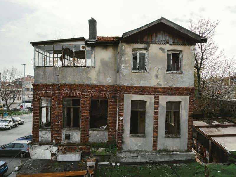
Older residential home awaiting renovation, illustrating why a boundary survey should verify property lines before remodeling or expanding the structure.

Older homes hold charm and history, but they also come with layers of changes made over many decades. What looks like a simple layout on the surface may hide shifts, additions, or adjustments that no one recorded. A boundary survey gives you the exact legal limits of your property before you break ground on any renovation. It clears up confusion and makes sure your plans stay within the lines that define your ownership.

Many homeowners start projects by looking at fences, old maps, or how things have always been arranged. These assumptions can lead to mistakes that cost time and money later. Taking the time to confirm boundaries first sets a solid base for every decision you make during the renovation.

Renovation Plans Often Outgrow the Original Property Layout

Over the years, older properties often change shape. Previous owners may have added rooms, built porches, extended garages, or moved walkways to fit their needs. They might have done this without checking official records or updating legal documents. Some changes sit just inside the lines, while others may creep closer or even cross into areas that belong to someone else.

When you plan a renovation, you usually want to expand or improve what already exists. If you build around structures that are not correctly placed, your new work will follow the same error. You may end up designing a project that looks good on paper but sits too close to or beyond your legal limits. Knowing the true layout before you draw plans keeps your ideas realistic and within rules.

Why Older Improvements Can Complicate Modern Renovation Projects

Driveways, retaining walls, sheds, and garden walls stay in place for years, so people begin to treat them as permanent markers of the property line. In reality, they were often placed based on guesswork or old measurements that are no longer accurate. Over time, soil shifts, materials settle, and original markers disappear, making it even harder to tell where the true edge lies.

These long-standing features can create problems when you want to replace or expand them. If you tear down and rebuild a wall that sits partially outside your boundary, you create a new issue that did not exist before. A boundary survey shows exactly where these structures stand compared to legal lines. This information helps you decide what to keep, what to move, and what to rebuild safely. You can rely on property boundaries to guide these choices.

Coordinating Architects, Contractors, and Surveyors Before Design Begins

Every person working on your project needs the same set of facts to do their job well. Architects need correct dimensions to draw plans that fit the lot. Contractors need clear lines to set foundations and place materials. Engineers need accurate limits to design drainage and support systems. Without shared data, each team may work from different assumptions, leading to conflicts and changes later.

A boundary survey provides one consistent source of information for everyone involved. It removes guesswork and lets all parties start from the same page. When you share these details early, designs stay aligned with reality and construction moves forward smoothly. This coordination saves time and reduces confusion throughout the entire process. You can trust survey measurements to keep the project on track.

Protecting Your Renovation Budget From Unexpected Property Constraints

Making changes once construction has started is expensive. If you discover halfway through a project that your addition sits too close to the edge, you have to redraw plans, buy new materials, and pay crews to adjust their work. These changes often add thousands of dollars to the final cost and push back your timeline.

Most of these surprises come from not knowing the exact limits of the property. Local rules about setbacks and easements also apply strictly, and they can limit how much you can build. A boundary survey reveals these constraints before you spend money on designs or permits. It helps you plan within what is allowed, so you avoid extra charges and delays that come from fixing mistakes.

Making Future Property Improvements Easier With Verified Boundary Information

Completing a boundary survey is not just for the current renovation. It creates a permanent record you can use for years to come. If you want to add more space, build a new structure, update landscaping, or sell the home later, you will have clear proof of where your lines run.

This record removes uncertainty for you and for anyone who works on the property in the future. It also makes selling easier, because buyers and lenders want confirmed boundaries before closing. Investing in this step now gives you flexibility and peace of mind for every change you make down the road. It turns a one-time task into a long-term benefit for your home and your investment.

Frequently Asked Questions

Should a Boundary Survey be completed before designing a major home renovation?

Yes, it is the best first step. It gives you the exact location of your property lines so you can design within legal limits. It also helps you follow local rules and avoid issues when applying for permits.

Can older additions affect future renovation plans if property boundaries haven’t been verified?

Yes. Older additions may sit too close to lines or even cross them. If you expand or modify them without checking, you could make a small problem larger and face costs to correct it later.

How does a Boundary Survey help architects during residential remodeling projects?

It provides accurate dimensions and locations of boundaries, easements, and existing structures. Architects use this data to create plans that fit the lot and meet local requirements without guesswork.

Will a Boundary Survey support permit applications for home additions or detached structures?

Yes. Most local offices require proof of boundaries before approving construction plans. A survey gives them the official details they need to review and approve your project quickly.

Can renovating an older property uncover boundary-related issues that weren’t previously noticeable?

Yes. Digging, grading, or removing old structures can reveal gaps between what was assumed and what is legally true. A survey spots these issues before work begins so you can address them early.

Is it beneficial to update boundary information before investing in extensive property improvements?

Absolutely. It protects your budget, keeps your plans valid, and prevents disputes. Having confirmed boundaries also adds value to your home and makes future work or resale much simpler.

Posted in boundary surveying | Tagged boundary survey

Post navigation

← Older posts
Newer posts →
Get Quote Button
© Boxer Survey USA
Cleveland Land Surveying

Cleveland, Ohio
Phone: (216) 208-7171

Web Development and SEO by:
AuburnBusiness.com, LLC


Privacy Policy | Terms of Use

The owner of this website, Boxer Survey USA, provides coordination of professional land surveying and engineering services in all 50 states. The professional surveying and engineering services provided to you will be conducted by fully licensed professionals in your state.

↑